
The City Council was able to get a glimpse of Turlock’s potential new electoral maps on Tuesday during the third of four public hearings, where citizens weighed in on the redistricting process and shared their thoughts on the preliminary drafts.
The redistricting process takes place every 10 years following the release of census data and, if needed, district lines are redrawn in order to reflect how local populations have changed. In the two meetings held prior to the release of three draft maps on Tuesday, citizens provided input on Turlock’s communities for the National Demographics Corporation to use when creating new boundaries.
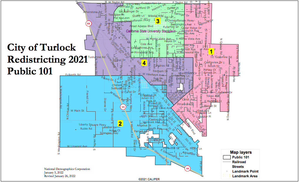
In addition to two draft maps created by NDC, labeled “Orange” and “Green,” Turlock resident Ron Bridegroom also drafted map Public 101. Though the three drafts were presented on Tuesday, the City Council won’t decide on a final map until their March 22 meeting.
Jeff Tilton of NDC explained that while the Council could elect to keep its districts as they are currently drawn, the map could be challenged legally because it does not contain a minority majority district, as required by the Voting Rights Act. While District 2 currently features a 49% Hispanic voting population, that number would need to be at least 50% in order to meet legal requirements.
The Orange and Green maps each tried to accomplish something different while still producing a minority majority district, Tilton said. In the Green map, NDC attempted to change the current districts as little as possible while still ensuring that one district, in this case District 2, would meet the threshold of 50% Hispanic voters. The Orange map features districts which stretch horizontally across the city, an intentional choice, with District 2 again featuring majority Hispanic voters.
“I’ve heard in a couple of the meetings I’ve attended that there’s an us versus them, the haves versus the have nots, and my district doesn’t get the same money as your district types of shots being fired,” Tilton said. “I thought maybe I could create a nice web not knowing where any Councilmember lives.”
In the Green map, there are some changes to each districts’ borders, but those living in the center-most portions of their districts won’t see theirs change. The most notable changes include District 4 losing Donnelly Park and some surrounding neighborhoods to District 1, and making up for the lost space by taking the northern half of the current District 2 and a western portion of District 3. District 2 instead stretches eastward into what is currently the southern tip of District 1 below East Avenue, while District 3 extends down to East Hawkeye Avenue between North Berkeley Avenue and Waring Road.

The Orange map, Tilton’s horizontal experiment, would see District 3 at its top, stretching from Highway 99 to just past North Berkeley Avenue. Below that is District 4, which stretches across the entirety of Monte Vista Avenue in town, in some parts reaching up to West Christoffersen Parkway and going down to Fulkerth Road in others.

Bridegroom’s map, Public 101, is the result of his participation in both public hearings so far and his effort to also keep the draft as close to the current district as possible.
His map would see central Donnelly Park remain in District 4, as well as communities in the central part of the city, and its northeastern-most portion instead moving into District 3. As a result of both shifts, District 1 would also move north up to Taylor Road after losing some of its western neighborhoods to District 4, and District 2 would remain almost unchanged, except for the addition of some land along Golden State Boulevard.
“I tried to keep the districts as much the same as possible so that people who were going to vote this year for a Councilmember weren’t moved into another district where they had to wait another two years,” Bridegroom said.
Though the Council did not yet select a map, Councilmember Andrew Nosrati said he had a favorite of the three drafts.
“I think Public 101, between that and the existing districts, is the most effective at achieving the goals that we’re looking for….it does a division of District 3, but it does so in a way that I think really does group together like-minded or similar community groups,” Nosrati said.
The Council will select a final map at 6:30 p.m. March 22, when another public hearing will be held. Community members can view the draft maps as well as the existing map at www.redistrictturlock.org