It appears that Mother Nature is serious about getting fully caught up on Central Valley rain totals.
After a mostly a dry start to 2026, the Turlock region was off nearly 2 inches from its historical rainfall average of about 5 inches for the first two months of the year.
But all that is about to change.
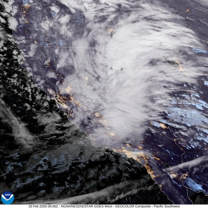
“For at least the short term, through Thursday, there’s a cold storm system that will impact Northern California and bring scattered showers to the valley and heavy snow to the foothills and mountains,” said Kristina Hand, meteorologist with the National Weather Service in Sacramento. “We’ll see that start to taper off Thursday night, with a bit of a break on Friday and Saturday, though we could see a few lingering showers in mountains. Then we’ll have another system move in Sunday night, bringing more rain to the valley and snow in the mountains, continuing into early next week.”
The NWS doesn’t forecast beyond seven days, but Hand said that the Climate Prediction Center has produced long-range outlooks based on probability.
“It’s not an exact forecast, but it does shows the odds are favoring above-normal precipitation through February and into March.”
All this is good news for farmers in the region.
According to a Turlock Irrigation District report presented to the Board of Trustees on Tuesday, the Tuolumne River Watershed is expected is receive 8-9 inches of precipitation over the next week and between 11-14 inches over the next 16 days.
“The average for February alone is 5 1/2 inches of precipitation in the watershed,” said TID spokesman Brandon McMillan. “And we’re at a little over half an inch as of Feb. 15. But if the forecast holds, it would bump us to an above-average February.”
As of Tuesday, Don Pedro Reservoir sat at a level of 802.9 feet — about a foot above the flood control line. Currently, TID is releasing 2,000 cubic feet per second into the Tuolumne River, though that number might need to be increased depending on the forecast and the observed conditions of the storm.
“Based on current models, we’ll be able to fill Don Pedro this summer,” said McMillan. “And we’re hopeful that we’ll be able to release a full 48 inches of water for growers. The board will make that determination at its March 3 meeting when it sets the irrigation season.”
Late in 2025 and at times in 2026, the valley experienced long periods of fog, the product of a high-pressure system that pinned down low-lying clouds.
According to Hand, this recent storm is the result of a low-pressure system swooping down from the Gulf of Alaska and bringing with it cold air and moisture.
“We haven’t had a storm this cold this winter,” said Hand. “For the Turlock area, we’re expecting low temps around freezing on Friday morning, so people will want people to take care of their pets and plants and prepare for those colder temperatures.”
Turlock will make warming centers available during this stretch of cold and rainy weather, according to Christopher Fisher, the city’s director of municipal services.
The Roger K. Fall Transit Center, 1418 N. Golden State Blvd., will be open Monday through Friday from 6 a.m. to 9 p.m., and on Saturday from 9 a.m. to 7 p.m. Also, the Turlock Public Library, 550 N. Minaret Ave., will be open Monday, Tuesday, and Thursday from 10 a.m. to 6 p.m., on Wednesday from noon to 8 p.m., and on Friday and Saturday from 10 a.m. to 5 p.m.
Millions of Los Angeles County residents faced flash flood warnings as rain pounded the region and people in some areas scarred by last year’s devastating wildfires were under an evacuation warning through Tuesday because of the potential for mud and debris flows.
The storm wreaked havoc on roadways spanning from Sonoma County to the Sierra Nevada. Traffic was halted temporarily in both directions on I-80 near the Nevada state line due to spinouts and crashes, the California Department of Transportation reported.
Forecasters said the western slope of the Sierra Nevada, and parts of the state’s Coast Range could see up to 8 feet of snow before the storm moves through tonight. The heavy snow, wind and low visibility could also make travel conditions dangerous to near impossible, forecasters added.
— The Associated Press contributed to this story.