
Five Geography majors at California State University, Stanislaus spent the semester biking around Turlock to help make the community a safer place. They surveyed existing bike routes and areas around town that could use bike paths to measure Turlock’s bikeability and propose new bikeways.
Ben Thompson, Ryan Rice, Jackson Parker, Chad King and Mitchell Medeiros presented their findings on Turlock’s bike paths to a group of students, Turlock city staff, and university faculty on Tuesday. The project was part of their final grade in Jennifer Helzer’s Urban Geography class. Four groups total presented their community-based projects, which all involved community partners. The point of the project was to use geospatial technology to help support community initiatives.
The Turlock bikeability group decided to gear their service learning project towards something that affects them personally. Several of the group members ride bikes regularly around town, and have noticed a lack of bike lanes and other areas safe for bike riding. In their presentation they said that 3.3 percent of employed Stanislaus County residents walk to work.
The Turlock master plan is in the revision process, and the classmates decided to make a plan for improved bikeways in Turlock city limits. They set out on their own bikes and surveyed several areas of town with and without bike lanes. They met twice with Turlock city planners and staff to review the current bike pathway plans for Turlock and explore areas where their project could help the city.
One thing the group noticed was that even some areas designated for bike lanes do not actually have painted lanes. They also found the current usage of bike lanes makes them less safe in real life than they seem in city plans.
“It’s one thing to look at plans and say ‘oh, this bike lane has five feet of clearance,’ but you don’t realize until you’re out there that it’s actually 2 feet in some places. Cars park in the bike lane and open their doors,” King said.
Turlock has three designations for bikeways. Level I bike paths are separated from the road, for example the bike path on Canal near Turlock High School. Level II bike lanes are separated from traffic with painted lines, but they share turn lanes and parking areas with cars. Level III bike routes are areas designated by signs where vehicles share the road with bicycles.
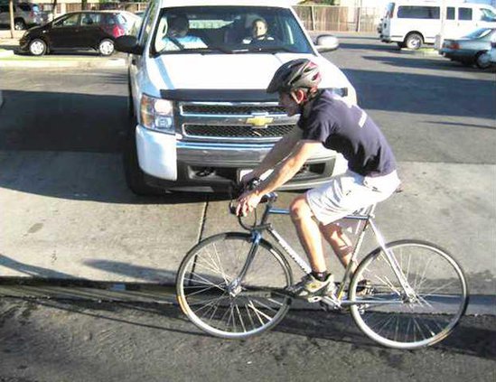
One area where the group would like to see improvements is on Golden State Boulevard. Parker rode the length of Golden State and took photos for the project. He said that parts of the street were “next to impossible” to travel on a bike. While he was taking photos he saw a man riding a bike over the South Golden State Boulevard overpass.
“This brave soul joined traffic and came barreling down the overpass,” Parker joked, “but really I feel like this guy is who we did this project for.”
The group would like to see their findings used to improve bike areas in Turlock. They suggested some areas where “sharrows” would be useful. Sharrows are symbols painted on the street that let motorists know that they are sharing the lane with bicyclers. They suggested sharrows for the downtown area, where there isn’t room for a designated bike lane.
Rose Stillo, senior planner with the City of Turlock, attended the presentation on Tuesday. As a graduate of CSU Stanislaus she was interested in the project. She said that it had applications for the current general plan regarding bike lanes in Turlock.
“These guys filled some gaps,” Stillo said.
To contact Andrea Goodwin e-mail agoodwin@turlockjournal.com or call 634-9141 ext. 2003.


